New Delhi, Jan 14 (IANS) The year 2023 has been confirmed as the hottest one on record, new data has confirmed, and scientists warn that 2024 could be worse.
From droughts and floods to more intense storms, countries around the world are already living with the impacts of climate change.
Science says today more than ever, the world needs urgent climate action -- reducing rapid fossil fuel emissions and adapting to the effects of climate change.
Here’s what that means and what we can do about it: As global temperatures continue to increase, we risk ever-rising sea levels, stronger storms, increased droughts, more frequent wildfires and even our health.
Ocean temperatures, which have been rising year-on-year for the past decade, have once again shattered records, a study by Advances in Atmospheric Sciences has found, warning that 2023 was the hottest on record for the world's oceans for the fifth year in a row.
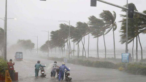
Cyclone Michaung, intensified by El Nino and soaring sea surface temperatures, wreaked havoc in India in 2023. The devastating storm, the sixth in India in a year, over the Bay of Bengal in December caused extremely heavy rains over the metropolitan city of Chennai in Tamil Naidu and the neighbouring state of Andhra Pradesh.
December is the peak month of the post-monsoon cyclone season, where most of the cyclonic storms usually head towards Tamil Nadu and south Andhra Pradesh.
While the formation of a tropical storm in the Bay of Bengal during December is very timely, the intensity of rains associated with the Cyclone Michaung is not normal, climate experts told IANS.
The frequency and intensity of cyclones, they say, has increased manifold owing to global warming as 93 per cent of the heat is being observed by the oceans, and warm waters act as an energy source for cyclones.
Scientists say the intensity of the cyclone depends not only on sea surface temperature but, more importantly, on the volume of warm water in the ocean.
According to a report, the increase in sea surface temperature could result in peak heavy rainfall in the tropical cyclone inner-core region, especially the rear sector.
Heavy rainfall areas extend to greater distances around the tropical cyclone centre. The observed changes of tangential wind speed due to large sea surface enthalpy fluxes (rate of flow of heat energy) associated with ocean warming result in tropical cyclone size changes and then guide the cyclone to north-eastward movement.
Similar conditions were seen in Chennai, which saw incessant rains on December 3-4 as the dense cloud bands of Cyclone Michaung hovered over the city.
El Nino, since the very beginning, has been in the news for its rapid intensification. Equatorial sea surface temperatures (SSTs) are above average across the central and eastern Pacific Ocean.
Nino 3.4, the representative of ONI (Oceanic Nino Index), has crossed two degrees Celsius for the first time since February 2016, after the super El Nino of 2015. Chennai recorded 292 mm rain on December 2, 2015, an all-time high record.
“El Ninos usually peak around Christmas in December, a reason why they derive their name from the Spanish term for ‘little boy’. As oceans absorb more than 93 per cent of the additional heat from global warming, El Ninos are also getting stronger. They are not little boys anymore but monsters of the sea,” explained Roxy Mathew Koll, Climate Scientist at the Indian Institute of Tropical Meteorology.
“Changes in ocean-cyclone interactions have emerged in recent decades in response to Indian Ocean warming and are to be closely monitored with improved observations since future climate projections demonstrate continued warming of the Indian Ocean at a rapid pace along with an increase in the intensity of cyclones in this basin,” Koll said.
Besides El Ninos, two important oceanic phenomena -- the Indian Ocean Dipole and Madden-Julian Oscillation -- both associated with positive rainfall over Indian landmass, were in favourable zones in December.
How is global warming changing the dynamics of cyclones for India? The large natural variability in a relatively short observational period makes it difficult to determine what percentage of the observed tropical cyclone activity changes can be attributed to ocean warming due to greenhouse gases.
The impact of SST warming on cyclone activity is not only related to the magnitude of the SST change but also associated with it pattern.
Recent observations, say scientists, indicate that cyclones in the north Indian Ocean are now exhibiting rapid intensification, intensifying by more than 50 knots in just 24 hours, in response to SSTs much higher than 30 degrees Celsius, prominently due to the rapid warming in the region.
From 2000 onwards, the frequency of cyclones undergoing rapid intensification in the north Indian Ocean has increased.
The percentage of cyclones undergoing rapid intensification in the north Indian Ocean is higher (38 per cent) than the cyclones in the northwest Pacific Ocean, where this rate is 22 per cent.
Due to the eastward shift of the cyclogenesis (development or strengthening of cyclonic circulation) location in the Bay of Bengal, the cyclones are now travelling for a long time over the ocean and drawing more of the thermal energy released from the warm ocean waters, enhancing the chances of developing into a very severe cyclone with intensity greater than 65 knots.
Besides the SST, the ocean heat content also regulates the tropical cyclone intensity, particularly for slowly moving cyclones.
The intensity of cyclones in the north Indian Ocean is governed not only by the SSTs but also by the high ocean heat content and warm, ocean subsurface. Ocean heat content acts as an essential parameter governing the lifecycle and intensity of cyclones in the north Indian Ocean.
High ocean heat content implies a warmer upper ocean, which helps cyclones sustain or intensify due to the uninterrupted supply of sensible and latent heat fluxes from the ocean surface to the atmosphere.
(Vishal Gulati can be contacted at gulatiians@gmail.com)

